WELLS, Maine — With a new golf course no longer a part of the proposed plans for Burnt Mill Estates, are there any new plans for the site?
A resident asked either the Wells Planning Board or Mathew Orr, of Sebago Technics, a civil engineer for the project, to provide insight into that question during a meeting earlier this week.
“Communication has been a little weak,” the resident said.
Orr replied that the official removal of the proposed golf course was the only aspect of Burnt Mill Holding Company’s application before the board that evening. The town of Wells sits near the Maine-New Hampshire border, just a few miles south of the tourist hamlet of Kennebunkport.
Nearly two decades ago, an announcement came that the development would include Burnt Mill Country Club, an 18-hole, 7,200-yard course, to be the second course created by the design team of 8-time PGA Tour winner Brad Faxon and golf architect Brad Booth. The complex was also slated to include a 9-hole par 3 short course, a practice range, and a 12,000 sq. ft. clubhouse.
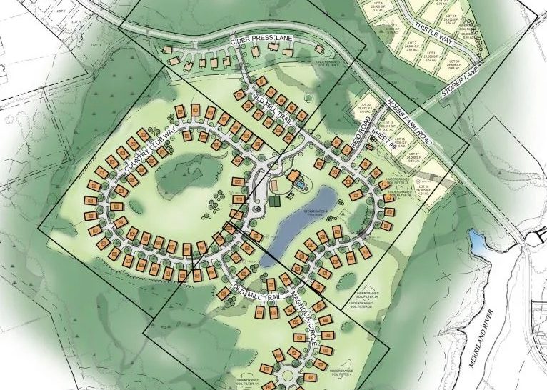
While the golf course is being eliminated from the proposal, the plan for 174 new dwelling units on 362 acres of land along Hobbs Farm Road has not changed, Orr confirmed.
“Any changes to any sort of amenities, or anything like that, would take place as part of the larger residential project, which is not in front of the board this evening,” Orr said.
Planning Board Chair Charles Millian pressed Orr further.
“So are you telling us there could be plans for future residential development there?” Millian asked.“I’m not aware of any at this time,” Orr replied.
On Wednesday, Town Engineer Mike Livingston said other amenities, originally proposed in the area of the golf course, are being consolidated and relocated in a separate plan amendment to redesign the development.
The future of the land once marked for 18 holes and more was not the only subject of concern during the Planning Board’s meeting on Oct. 31. Questions regarding a proposed walkway and drainage for the project also persisted – enough so that board members decided, unanimously, that they needed to take another site walk along the property.
“We really need to go out there,” Millian said.
The board members will take that site walk on Hobbs Farm Road next Saturday, Nov. 12, at 9 a.m. The public is invited to attend.
Residents concerned about walkway, drainage
Board members want to see the route along which a new walkway is proposed to be built. According to Town Engineer Mike Livingston, the walkway would start on the northeast side of Hobbs Farm Road and would continue past Little Meadow Court. The path would switch to the other side of the road, once it approaches Lot 54, near Cider Press Lane, on the town map. The walkway then would continue on that side, all the way to the nearby bridge.
Another resident asked why the walkway is proposed to cross Hobbs Farm Road to the other side at one point, especially given that 174 new homes are slated to be built in the area.
“Having people crossing back and forth across a road with a 35-mile-per-hour speed limit is not a good idea,” the resident said. “It just sounds like an astronomical amount of future traffic coming down a narrow, two-lane country road.”
Livingston explained that the walkway originally was designed to accommodate the golf course. When asked about a traffic study at the site, Livingston replied that two already have been done for the Burnt Mill Estates project – one in 2008, when at first the proposal included the golf course and 85 dwelling units, and again in 2015, when that number of units increased to 174.
Livingston added that safety was one of the reasons why the Planning Board required that the walkway be a part of the project back in 2015.
Currently, Hobbs Farm Road is about 21 or 22 feet wide, paved, and with a slight gravel shoulder. According to Livingston, the walkway is written into the deeds of the property owners along the proposed route.
Livingston added that there is about 10 to 12 feet of public right-of-way space along the road, as well as a 10-foot easement. Such land is either owned by the town or covered by the developer’s easement. Homes were built close to the front-yard setback, Livingston said.
“I think one of the major misconceptions is that people who bought these lots think they own to the edge of the pavement,” Livingston said. “They do not.”
During the site walk, Planning Board members also will look at new drainage measures slated for the project to address stormwater pooling in the area. In particular, the board will examine a site slated for a detention pond near one homeowner’s property.
The homeowner expressed concern that the pond would encroach upon his yard and come closer to the deck where he and his wife like to sit and relax or grill burgers. He suggested grading measures as an alternative to a pond that takes up more space. He said the pond, as proposed, would change and limit the use of his property.
“We’re opposed to that,” he said.
Residents expressed their concerns during a public hearing that preceded the board’s workshop on the Burnt Mill Estates proposal. The board’s meeting packet also included emails from residents, who expressed similar concerns related to property lines, the proposed walkway, removal of trees, and communication issues.
The town’s staff review committee, comprised of Livingston, Assistant Planner Shannon Belanger, Police Chief Jo-Ann Putnam, Fire Chief Mark Dupuis, Road Commissioner Carol Murray, and Code Enforcement Officer Jodine Adams, will turn their attention to the project sometime after the Planning Board’s site walk.